|
Inland from Common Edge Lane lay Marton Moss which over the
centuries had been drained and cultivated.
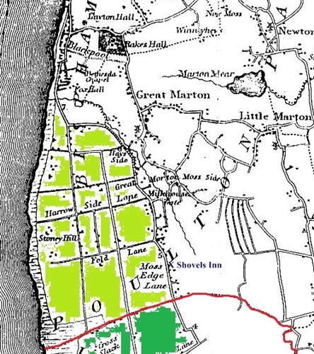
For centuries, the land between Common Edge Lane and the
sea was a vast expanse of common land known as Layton Hawes. It was poor
pasture land because large sand dunes had smothered the coastal stretch and the
rest was overblown by sand; the area known as Blowing Sands is over a mile from the
coast.
From the 1760s, Layton Hawes was drained, fenced and long,
straight lanes were constructed. The land was sold or leased to farmers and new
farmhouses and workers cottages were built.
By the 1860s, along the coast, the South Shore area of Blackpool
was evolving and over the next hundred years the lanes, fields and farms gave way
to streets, houses and shops.
|
Blackpool c1830 - the
area shaded light green was Layton Hawes which was open common until it was
enclosed from the 1760s onwards. The area today comprises all of South Shore and
part of Central Blackpool including St.Annes Road and Lytham Road (the two long
lanes running north-south). Common Edge Lane runs along the right hand side with
Marton Moss inland. Along the coast is a belt of sand dunes which stretched from
what is now Manchester Square, southwards, as far as Lytham and the River
Ribble.

|